General information on maritime spatial planning
The objective of the maritime spatial plan is to promote the sustainable development and growth of the different uses of the sea area, the sustainable use of the marine resources of the sea area and the achievement of good environmental status in the marine environment. Maritime spatial planning is based on the EU Maritime Spatial Planning Directive and regulated in Finland the Land Use Act.
Maritime spatial planning coordinates the different needs for the use of marine areas, both from the point of view of maritime livelihoods and the environment. In particular, the energy sector, maritime transport, fisheries and aquaculture, tourism and recreation, conservation, protection and improvement of the environment and nature will be examined. Attention will also be paid to the needs of national defence, the characteristics of the maritime area and the interaction between land and sea. Other themes such as cultural heritage, extractive industries, blue biotechnology or maritime industries will also be addressed.
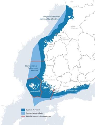
The Finnish maritime spatial plan is drawn up and approved by the Regional Assemblys of the coastal regions. The plan is a strategic vision, formed together in cooperation in cooperation with stakeholders, for the sustainable use of the marine area and for supporting the good environmental status of the marine environment. The maritime spatial plan does not have legal effect in the same way as the regional or general plans, but it has indirect steering effects. The plan is drawn up in three parts and covers Finland's entire sea area, i.e. Finland's territorial waters and exclusive economic zone. The Regional Assembly of Northern Ostrobothnia prepared a joint maritime area plan in cooperation in cooperation with the Regional Assemblys of Lapland, Central Ostrobothnia and Ostrobothnia for the planning area of the North Bothnian Sea, the Kvarken and the Bothnian Bay. Read more about the maritime spatial planning process on the website www.merialuesuunnittelu.fi
Planning areas and the Regional Assemblys responsible for them
- Gulf of Finland: Regional Assemblys of Kymenlaakso and Uusimaa
- Archipelago Sea and South Bothnian Sea: Regional Assembly of Southwest Finland and Regional Assembly of Satakunta
- North Bothnian Sea, Kvarken and Bothnian Bay: Regional Assemblys of Ostrobothnia, Central Ostrobothnia, Northern Ostrobothnia and Lapland
At the end of 2020, the current maritime spatial plan has been approved by the Regional Assemblys of the Coastal Region. Finland's maritime spatial plan 2030. On the website you will find a valid maritime spatial plan in cooperation in cooperation with background information.
Updating of the maritime spatial plan is ongoing
Since the adoption of the current maritime spatial plan, the business environment has undergone major changes. EU regulations have been renewed, the targets for marine energy production have increased, climate change has progressed faster than estimated, and the importance of shipping and marine food production, for example, from the point of view of security of supply, has increased.
| The sea is for everyone - Havet är för alla The core message of maritime spatial planning is: “Maritime spatial planning establishes a common vision among maritime stakeholders on the sustainable use of the maritime space. The goal of maritime spatial planning is a prosperous, productive and safe sea. Together planning, recognizing the future!‘ |
Preliminary draft maritime spatial plan completed
A preliminary draft of the maritime spatial plan was published in a joint webinar on maritime spatial planning and coastal strategy open to all on 16 June 2026. A recording of the event has been published.
After the Publication Webinar the recording and the material of the preliminary plan can be consulted online;, which also includes a comment form. The preliminary plan is open for comments until 31.8.2026. The feedback received will be taken into account in the preparation of the actual draft plan in autumn 2026. The actual draft plan will be made available to the public at a later stage, where it can be consulted and feedback can be provided. The update is expected to be completed in 2027.
Coordinating national cooperation in the MSP-EGD project
The second cycle of maritime spatial planning cooperation is funded by the European Maritime, Fisheries and Aquaculture Fund (EMFAF) through the MSP-EDG project. The MSP-EGD1 project (2023-2026) will ensure the integration of maritime spatial planning and maritime spatial plans into the European Green Deal’s target setting, thereby supporting the green transition of society through maritime spatial planning. The MSP-EGD2 project (2026-2027) will continue and in particular deepen the contents of the previous EGD project.

Ongoing international EU projects
SEABAS Project Platform
The SEABAS project (2025-2027) creates recommendations for the Baltic Sea region and a common reference framework for assessing the impact of maritime spatial plans. The main elements of the package are the assessment of cumulative impacts, transboundary impacts and consultation processes. The recommendations created in the project will be tested in Finland in a national-level maritime spatial planning pilot. The project is funded by Interreg Baltic Sea Region.

Oceanids
The OCEANIDS project (2023-2026) creates user-driven tools and applications for climate-conscious maritime spatial planning and integrated maritime landscape management. The aim is to collect, harmonise and aggregate climate data from European sea basins to make them accessible and usable for climate adaptation. The aim is also to promote a sustainable blue economy in coastal areas.

More information on EU maritime spatial planning projects here.
Additional information
Land Use Manager Rauno Malinen, +358 50 4330306, rauno.malinen@pohjois-pohjanmaa.fi
Contact information for maritime spatial planning coordination, responsible authorities and other regional marine spatial planning officers can be found at: here.